The pressure on businesses to demonstrate accountability in Environmental, Social, and Governance (ESG) practices is mounting. Integrating ESG principles into development strategies has become essential for addressing global challenges such as climate change, social inequality, and the growing demand for transparency in corporate governance.
Geospatial technologies, including Geographic Information Systems (GIS), remote sensing, and spatial data analytics, have emerged as critical tools that support businesses in assessing environmental impacts, optimizing operations, and advancing sustainable development.
Geospatial ESG is the integration of ESG and geospatial technologies, not only helps organizations comply with regulatory requirements but also creates opportunities to enhance operational efficiency, ensure data transparency, and design more effective decarbonization strategies.
Let us explore how geospatial technology is reshaping the way businesses approach ESG and implement their emission reduction goals in a sustainable manner.
What is ESG?
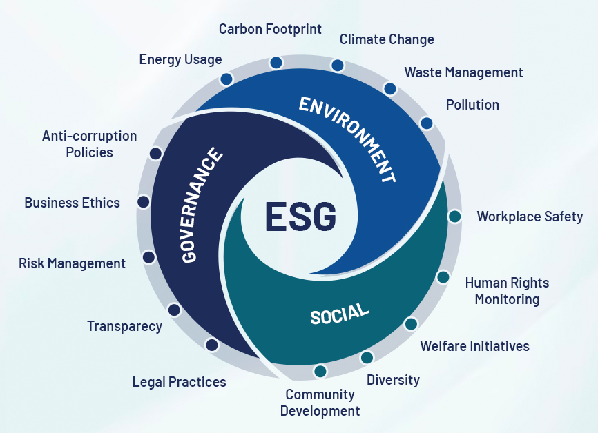
ESG stands for Environmental, Social, and Governance – a set of criteria used to evaluate a company’s sustainability performance and ethical impact. These three pillars have become increasingly important in guiding decision-making among investors, regulators, and other stakeholders when assessing a company’s operational effectiveness, regulatory compliance, and social responsibility.
- The Environmental component refers to how a business manages and mitigates its impact on the natural environment. This includes areas such as greenhouse gas emissions, energy consumption, natural resource management, biodiversity conservation, and climate change adaptation.
- The Social dimension focuses on how a company interacts with people and society. It encompasses issues such as labor conditions, human rights, employee health and safety, community engagement, diversity and inclusion, and relationships with customers and business partners.
- The Governance aspect relates to internal corporate structures, ethical standards, and control mechanisms. Key considerations include transparency, accountability, board composition, shareholder rights, anti-corruption practices, and legal compliance.

ESG is essential in today’s business landscape as it addresses critical concerns such as sustainability, regulatory adherence, risk management, and stakeholder expectations. By prioritizing ESG, companies can become more resilient, responsible, and competitive — better positioned to thrive in an evolving global economy.
Emissions reduction and sustainable development: Challenges and the critical role of geospatial technology
Greenhouse gases, particularly carbon dioxide (CO₂), are the primary drivers of global climate change. Notably, the built environment, including residential buildings, commercial centers, factories, and infrastructure, accounts for up to 39% of global CO₂ emissions, stemming from both direct and indirect energy consumption. The growing concentration of CO₂ in the atmosphere contributes to global warming, sea level rise, extreme weather events, biodiversity loss, and food security crises.
In response, measuring and monitoring carbon emissions, also known as the carbon footprint, has become a top priority in global emissions reduction strategies. However, this remains a significant challenge due to the limitations of traditional methods such as manual surveys, specialized measurement equipment, and 3D laser scanning, which are costly and difficult to scale.
In this context, geospatial technology, including remote sensing, Geographic Information Systems (GIS), and satellite sensors, offers a cost-effective and efficient alternative. These tools enable real-time data collection and analysis of emission patterns, accurate identification of emission “hotspots,” evaluation of energy-saving initiatives, and support for ESG reporting and carbon reduction strategy development. According to estimates, the application of geospatial technology can reduce data collection costs by up to 60% compared to conventional methods.
In Vietnam, the drive for emissions reduction and sustainable development is not just a global trend but a national imperative, codified through numerous resolutions and strategies on green growth, most notably, the commitment to achieve net-zero emissions by 2050. Within this framework, geospatial technology plays a key role in monitoring natural resources, tracking deforestation, water consumption, greenhouse gas emissions, and other environmental indicators with high resolution and the ability to integrate multi-source data, from satellites and aerial imagery to mobile LiDAR.
Beyond environmental monitoring, geospatial technology also empowers the “Social” pillar of ESG by mapping underserved areas, analyzing gaps in basic services, and monitoring labor conditions across supply chains. These capabilities help ensure the protection of human rights and foster harmonious development with local communities.
As international regulations such as the EU’s Corporate Sustainability Reporting Directive (CSRD) and the Task Force on Climate-related Financial Disclosures (TCFD) grow more stringent, the adoption of geospatial technology will become a strategic enabler for Vietnamese enterprises. It will not only support global compliance but also enhance competitiveness, reputation, and social responsibility on the journey toward Net Zero and sustainable development.

Integrating Geospatial ESG into Corporate ESG Compliance Strategies
An effective spatial data management system plays a crucial role in assisting enterprises to implement and comply with ESG criteria. Such a system enables the collection, analysis, and visualization of spatial data related to ESG factors, thereby improving the quality, accuracy, and reliability of information. As a result, businesses can identify potential ESG risk areas, develop strategies to mitigate adverse impacts, and generate detailed ESG reports enriched with maps, visual imagery, and quantitative analyses to support data-driven decision-making.
Environmental sustainability
- Resource Management: Geospatial data helps companies monitor and optimize the use of natural resources. For example, in agriculture, satellite imagery and GIS data can be utilized to adjust fertilizer and irrigation levels appropriately, thereby minimizing waste and reducing negative environmental impacts.
- Climate Change Mitigation: Spatial tools enable businesses to track greenhouse gas emissions accurately. This allows for identifying key emission sources, quantifying carbon output, and implementing reduction measures aligned with sustainability goals and ESG strategies.
- Ecosystem Conservation: Spatial data assists in identifying areas of high biodiversity value and sensitive ecosystems. Consequently, enterprises can plan operations to avoid environmental damage and demonstrate their commitment to environmental protection.
Social responsibility
- Supply Chain Transparency: Geospatial data supports product and raw material traceability, ensuring that production and supply processes comply with ethical standards, fair labor practices, and social responsibility.
- Community Engagement: Spatial analysis enables companies to identify, map, and assess communities affected by their business activities. This facilitates the formulation of appropriate policies to build positive relationships and enhance community participation.
- Health and Safety Protection: Spatial data aids in assessing the impact of corporate activities on living environments and public health. For example, it can identify pollution sources or evaluate exposure to health hazards in residential areas near industrial sites.
Governance and accountability
- Compliance Monitoring: Spatial data supports enterprises in tracking land use, zoning, and adherence to environmental regulations and current laws, thereby reducing legal risks and ensuring compliance with domestic and international standards.
- Risk Assessment: Spatial analysis allows the identification of potential risks related to assets, infrastructure, and operational activities. This information is vital for developing risk prevention and response plans consistent with modern governance principles.
- Stakeholder Communication: Visualization tools for spatial data help companies clearly and transparently convey their ESG efforts to investors, regulators, and the public. Maps, charts, and illustrative imagery simplify complex information, enhancing stakeholder accessibility and understanding.
How does geospatial technology support ESG reporting and measurement?
One of the greatest challenges in implementing ESG initiatives is the ability to measure and report progress accurately, transparently, and verifiably. Traditional reporting methods often rely on static data self-reported by companies, which can be inconsistent and may not fully reflect the actual situation.
Geospatial technology, with its capability to collect, analyze, and visualize real-time data tied to specific locations, offers a new, more objective, and reliable approach to ESG reporting. Through data sources such as satellite imagery, thematic maps, and Geographic Information Systems (GIS), businesses can provide visual evidence of the environmental impacts of their operations. This enables stakeholders, investors, communities, and regulatory agencies to easily verify, monitor, and assess performance.
Integrating geospatial platform into ESG reporting systems not only adds spatial depth to analysis but also enhances the accuracy and timeliness of reported data. This contributes to increased transparency, strengthens stakeholder trust, and elevates corporate accountability in fulfilling sustainable development commitments.
The future of geospatial ESG in advancing sustainable development
Amid the global push to accelerate emission reductions and achieve Net Zero emissions by 2050, geospatial technology is increasingly affirming its role as a strategic tool supporting businesses in meeting ESG goals and decarbonization roadmaps. With its capabilities to monitor, track, and analyze spatial and real-time data, this technology enables enterprises to effectively control emissions, optimize resource usage, and minimize environmental impacts.
However, the widespread adoption and application of geospatial technology remains limited due to various challenges such as insufficient data infrastructure, technical capacity constraints, and inadequate awareness among businesses. In the context of increasingly stringent environmental and social compliance regulations, integrating geospatial technology is no longer an optional trend but has become a mandatory requirement for organizations aiming for sustainable development.
Future trends indicate a strong convergence of geospatial technology with other advanced technologies such as Artificial Intelligence (AI), machine learning, and Big Data analytics. This integration will expand predictive analytical capabilities, enabling businesses to proactively identify potential ESG risks and support faster, more accurate decision-making.