Satellite imagery plays a vital role in modern life, from everyday applications to advanced geospatial analysis. While platforms like Google Earth offer free, user-friendly access for general use and education, commercial services such as GEOHUB deliver high-resolution, frequently updated data with powerful analytical tools tailored for professional needs like urban planning, agriculture, and environmental monitoring.
For newcomers, Google Earth is a great starting point. However, specialized projects demand a deeper understanding of each platform’s capabilities, especially in resolution, update frequency, and data processing.
This article highlights the key differences between Google Earth and commercial satellite imagery to help you choose the right tool for your goals.
Disadvantages of Google Earth you should consider
Image update cycle
One of the most notable limitations of Google Earth lies in its satellite imagery update cycle. While many users expect real-time satellite imagery access, the reality is that the platform updates data on a periodic basis – typically every 6 to 12 months. Urban areas are usually prioritized for more frequent updates, whereas rural, mountainous, or sparsely populated regions may go years without any updates.
For applications that require continuously updated ground information, such as monitoring construction progress, assessing environmental impacts, or tracking urban expansion—this delay can significantly affect the accuracy of analysis and decision-making. This is why commercial platforms, which offer on-demand data acquisition and more flexible update schedules, are often preferred for real-time or time-sensitive geospatial projects.
Spatial resolution and image
Quality Spatial resolution and image quality are critical factors in leveraging remote sensing data for advanced analytical purposes. Google Earth provides imagery with resolution varying by region, ranging from approximately 15 meters per pixel in remote areas to around 15 centimeters per pixel in major urban centers. However, these images are typically compressed and optimized for web-based visualization, which results in reduced quality for detailed analysis.
In contrast, commercial platforms such as Maxar, Airbus, or Planet Labs offer consistently high-resolution imagery, reaching up to 30 centimeters per pixel, and grant users access to raw satellite data. These uncompressed datasets retain full spectral values, making them highly suitable for advanced analytical applications such as object classification, thematic mapping, or high-accuracy change detection.
Geometric accuracy: A limitation for professional applications
When it comes to advanced applications such as urban planning, infrastructure design, or scientific research, the geometric accuracy of satellite imagery becomes a critical factor. Google Earth is primarily designed for visualization and general user experience, and the displayed imagery is not always rigorously ortho-rectified according to strict technical standards. This can result in significant positional errors, especially in areas with complex terrain or substantial elevation changes.
In contrast, commercial satellite imagery platforms such as Maxar, Airbus, and Planet provide geometrically corrected images using Digital Elevation Models (DEMs) and Ground Control Points (GCPs), ensuring positional accuracy of less than 5 meters, and in some cases, even under 1 meter for premium imagery. As a result, these datasets are widely used in:
- Infrastructure design and monitoring
- Legal mapping, land use boundaries, and property ownership
- Environmental assessment and land change analysis
- Geographic scientific research and spatial modeling
- Urban planning and sustainable development management
High geometric accuracy reduces the need for costly field surveys, enhances the reliability of input data, and significantly improves the efficiency of analysis and decision-making processes.
Advanced analytical capabilities
Google Earth provides satellite imagery that is valuable for reference and visualization; however, it lacks support for in-depth spectral or real-time data analysis. This makes it unsuitable for research-intensive or long-term monitoring tasks. In contrast, commercial platforms offer access to multispectral and hyperspectral imagery, along with raw data for customized processing techniques. Key capabilities include:
Vegetation analysis
Indices such as NDVI (Normalized Difference Vegetation Index), EVI (Enhanced Vegetation Index), and SAVI (Soil Adjusted Vegetation Index) are critical tools in precision agriculture, forestry, and ecological studies. These require detailed, well-calibrated spectral data, something Google Earth cannot provide. In comparison, imagery from satellites such as Sentinel-2, PlanetScope, and WorldView enables high-accuracy assessments of crop health, forest canopy dynamics, and biological changes over time.
Change detection and analysis
Temporal change detection is one of the most powerful applications of commercial satellite imagery. With access to high-frequency time-series data, users can:
- Detect land use and land cover changes
- Monitor urban expansion
- Assess disaster-related damages
- Track ecological restoration progress
The ability to retrieve imagery from specific time points and quantitatively analyze changes provides a significant advantage for projects that require continuous monitoring and detailed reporting to stakeholders.
Data integration and accessibility
While Google Earth offers an intuitive, web-based interface that is easy to navigate, it presents significant limitations in terms of data access and integration into professional systems. Users are restricted to basic measurement tools and cannot download high-resolution imagery for advanced processing. Furthermore, it lacks full support for standard GIS formats and API connectivity, making it unsuitable for integration into large-scale geospatial data analysis workflows.
In contrast, commercial platforms provide significantly greater flexibility through direct data downloads, GIS software integration, and API access for automation. This integration capability allows organizations to seamlessly incorporate satellite imagery into their existing workflows and systems.
The ability to batch-process imagery and perform automated analyses greatly reduces time consumption for large-scale projects. In addition, dedicated technical support ensures that user inquiries are addressed promptly, minimizing project delays and improving operational efficiency.
Cost: free doesn’t always mean effective
The fact that Google Earth is available free of charge is undoubtedly an advantage for individual users or educational purposes. However, for organizations or specialized projects, the true cost lies not only in the monetary aspect but also in the value and reliability of the data. Low-accuracy imagery, outdated datasets, or limited analytical capabilities can lead to errors, project delays, and increased operational costs during implementation.
Google Earth falls short for advanced use cases
Google Earth is well-suited for basic visualization, educational purposes, or preliminary research. However, when applied to real-world scenarios requiring high-precision data and in-depth analysis, the platform quickly reveals its limitations.
In contrast, commercial satellite imagery proves invaluable across a wide range of sectors. It offers continuous, high-accuracy updates essential for monitoring construction dynamics and designing transportation networks in urban planning and infrastructure development. Near real-time imagery and change detection capabilities support damage assessment and relief planning during emergency response. Broad-spectrum data such as NDVI, land surface temperature, and soil moisture are instrumental in crop health monitoring and optimizing irrigation strategies.
To give you a clearer picture of how our smart geospatial platform, GEOHUB, solves real-world challenges, we have prepared a set of GEOHUB Case Studies across various domains. Would you be interested in exploring them?
Challenges for non-technical
Users Another notable limitation of Google Earth is that its interface and toolset are not optimized for users without a technical background. Tasks such as data extraction, analysis, measurement, or visualization often require foundational knowledge in GIS or satellite image processing.
In contrast, many modern geospatial platforms, such as GEOHUB are designed to democratize the use of satellite data, offering a more user-friendly and accessible experience for general users.
What makes the GEOHUB Smart Geospatial Platform Different?
Both Google Earth and GEOHUB harness the power of remote sensing technology to deliver a global perspective of the Earth from space. These platforms are internet-accessible, allowing users to conveniently monitor locations around the world. However, their similarities largely end there. The key differentiator for GEOHUB lies in its superior flexibility and customization capabilities.
With an ever-expanding network of global partners, GEOHUB enables users to access satellite imagery from virtually any location on the planet. Notably, the GEOHUB VmRS system, an advanced multi-source virtual receiving station platform, is designed to support user-defined tasking, allowing users to request satellite imagery for specific areas, with selectable resolution and time windows. Once processed, these images can be purchased at reasonable costs and downloaded directly to personal devices. This empowers users with an unprecedented level of control, particularly valuable for projects requiring timely, high-accuracy data.
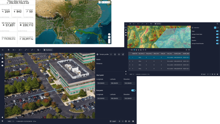
While Google Earth functions primarily as a free geographic browser aimed at public access and basic information retrieval, GEOHUB positions itself as a professional-grade geospatial platform. It serves enterprises, research institutions, and even newcomers to the field of Earth observation. Industries such as real estate, finance, energy, and infrastructure planning can leverage GEOHUB’s advanced analytics and specialized data to monitor assets, track on-the-ground performance, and make strategic, data-driven decisions.
GEOHUB expands the application potential of satellite data. With up-to-date imagery, advanced analytical capabilities, and expert support, GEOHUB is a powerful tool for visualizing and understanding Earth’s dynamic changes more effectively and intuitively.
If you’re interested in satellite tasking on our GEOHUB platform, please leave your information in the consultation form. Our geospatial experts will get in touch and support you promptly!