Although remote sensing satellites possess remarkable observational capabilities, they still face a critical limitation: they cannot simultaneously provide images with both high spatial resolution and high spectral resolution.
Typically, satellite images fall into one of two categories:
- Panchromatic images offer high spatial resolution but low spectral resolution.
- Multispectral images provide high spectral resolution but low spatial resolution.
This leads to a fundamental challenge in satellite image processing: how can we leverage the advantages of both data types? The answer lies in pansharpening – a technique that fuses panchromatic and multispectral images to produce an output with enhanced spatial and spectral resolution.
So, what exactly is pansharpening? How does it work, and what role does it play in improving satellite imagery quality? In this article, we will explore the essence of pansharpening, its operating principles, and its key real-world applications.
What is pansharpening?
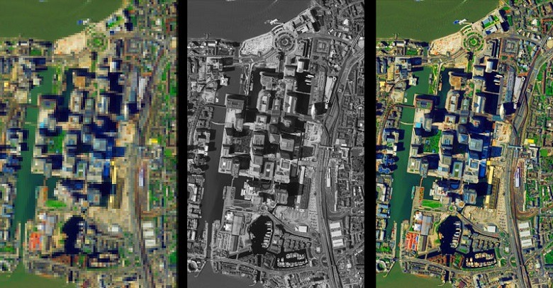
Pansharpening, short for panchromatic sharpening, is an image processing technique used to enhance the quality of satellite imagery by combining information from both panchromatic and multispectral images. In other words, this technique utilizes the spatial detail from the panchromatic image to “sharpen” the multispectral image, while preserving its spectral information.
The pansharpening process involves merging a high-spatial-resolution panchromatic image with a multispectral image that has high spectral resolution but lower spatial resolution. The result is a multispectral image with spatial resolution comparable to the panchromatic image, where both image layers are perfectly aligned.
Technically, pansharpening is a radiometric transformation that can be performed using raster functions or geoprocessing tools. Many satellite imagery providers offer data in the form of high-resolution panchromatic images and lower-resolution multispectral images of the same scene, enabling users to apply pansharpening techniques to enhance the quality of the final imagery output.
Why is pansharpening necessary?
Remote sensing satellites often face a fundamental limitation: they cannot simultaneously capture imagery with both high spatial and high spectral resolution. As a result, satellite imagery typically comes in two separate forms:
- Panchromatic images: These have high spatial resolution but contain information from only a single spectral band, usually appearing as black-and-white images.
- Multispectral images: These provide rich spectral (color) information but with lower spatial resolution.
Imagine having two images of the same area: one is a sharp black-and-white image, and the other is a color image with less detail. Pansharpening enables the fusion of these two images into a single composite image that retains both high spatial detail and vibrant spectral information.
Thanks to pansharpening, we can observe Earth’s surface features with greater clarity. This significantly improves the performance of satellite image analysis systems, whether human or machine, by making the data easier to interpret and process.
The history of pansharpening
The origins of pansharpening trace back to the 1970s and 1980s, when satellites began capturing both panchromatic and multispectral imagery. Early research focused on combining high-resolution panchromatic data with lower-resolution color information.
Key techniques such as the Intensity-Hue-Saturation (IHS) transformation and the Brovey transform were developed in the 1990s, paving the way for the widespread adoption of pansharpening in the 2000s, particularly with the emergence of high-resolution commercial satellites.
The benefits of pansharpening in satellite imagery
Pansharpening significantly enhances the quality and usability of satellite imagery by combining the high spatial resolution of panchromatic images with the rich spectral detail of multispectral images. This hybrid image supports better visual interpretation and more accurate automated analysis.
Enhancing visual interpretation
Capability Visual interpretation of satellite imagery involves identifying objects based on factors such as shape, size, texture, color, pattern, shadow, and spatial relationships.
Increasing spatial resolution enables more detailed representation of ground features, enhancing the ability to distinguish between closely spaced objects. This is particularly useful for identifying small features such as vehicles, roads, or individual trees.
Improved spectral resolution allows for more accurate simulation of real-world colors, thereby enhancing the ability to recognize features based on color characteristics.
By enhancing the spatial resolution of multispectral images, pansharpening significantly improves the visual interpretability of satellite imagery, benefiting both human analysts and automated systems.
Pansharpening enhances the performance of Image
Processing Algorithms Improved Accuracy in Training AI and Machine Learning Models
- Creating training datasets with more accurate labels enables machine learning algorithms to achieve higher performance.
- Pansharpening improves the accuracy of segmentation, classification, and feature extraction models applied to satellite imagery.
Improved automatic object detection
High spatial resolution imagery enhances the performance of object detection algorithms. This is because these algorithms rely not only on the spectral signature of individual pixels but also on the shape and structure of pixel clusters with similar spectral characteristics.
For example, rooftops and asphalt roads may exhibit similar spectral reflectance, but algorithms can distinguish them based on their shapes—rooftops typically have rectangular forms, while roads are elongated and narrow.
As a result, pansharpening improves the ability to differentiate between closely located features, increasing the accuracy of applications such as ship, vehicle, or building detection in satellite imagery.
Pansharpening enhances satellite image
Classification Multispectral images capture different wavelengths of the electromagnetic spectrum, enabling the classification of land cover based on the spectral characteristics of each object. However, low spatial resolution can reduce the accuracy in identifying the shapes and boundaries of classified areas.
Using only panchromatic images, despite their high spatial resolution, is challenging for distinguishing land cover types due to their low spectral resolution (containing only brightness intensity data).
In contrast, pansharpening combines the advantages of both—high spectral resolution and high spatial resolution—allowing for precise delineation of areas occupied by different land cover types and improving the accuracy of classification algorithms.
Pansharpening enhances temporal resolution for change detection
Earth observation satellites play a crucial role in monitoring changes over time, thanks to their regular observation schedules. However, the ability to detect changes depends heavily on the satellite’s temporal resolution.
For example, the MODIS satellite has a revisit period of 1 day, Landsat 8 revisits every 16 days, and Sentinel-2 every 5 days. To monitor rapid phenomena such as deforestation, urbanization, or agricultural changes, higher image acquisition frequency is needed.
Additionally, higher temporal resolution increases the likelihood of obtaining cloud-free satellite images.
However, satellites with high temporal resolution often have lower spatial resolution. For example:
- MODIS spatial resolution ranges from 250m to 1000m.
- Landsat 8 spatial resolution ranges from 15m to 30m.
- Sentinel-2 spatial resolution ranges from 10m to 60m.
One solution to improve the frequency of high spatial resolution images is to combine images from satellites with high temporal resolution with those having high spatial resolution. For instance, Landsat 8 images (30m) can be sharpened using Sentinel-2 images (10m), which:
- Increases the number of image acquisitions per month to 8 times (compared to 2 times for Landsat 8 and 6 times for Sentinel-2).
- Improves the ability to detect smaller and more precise changes compared to original Landsat 8 images.
Thus, pansharpening not only enhances spatial resolution but also contributes to continuous monitoring capabilities, meeting the detailed observation needs for environmental and resource changes.
How does pansharpening work?
One of the common methods for performing pansharpening is the Intensity-Hue-Saturation (IHS) technique. This method improves the spatial resolution of multispectral images while maintaining color accuracy. The process consists of three main steps:
Step 1: Transform multispectral data into the IHS
Color Space Multispectral images typically consist of three color channels (Red, Green, Blue) with spatial resolution lower than that of the panchromatic (PAN) image. To enhance sharpness, the multispectral image is first resampled and then converted from the RGB color space to the IHS color space.
- Intensity (I): Represents the brightness of the image.
- Hue (H): Determines the dominant wavelength, representing the color perceived by the human eye.
- Saturation (S): Measures the vibrancy or purity of the color.
Separating these components allows for independent processing of spatial information (brightness) and spectral information (color).
Step 2: Fusion with the panchromatic image
In this step, the low-resolution Intensity (I) component of the multispectral image is replaced with the high-resolution panchromatic image. This process enhances the sharpness of the image without affecting the original hue and saturation. As a result, the output image retains its rich spectral information while significantly improving spatial detail.
Step 3: Conversion from IHS back to RGB
After merging with the high-resolution panchromatic data, the high-resolution IHS image is converted back to the RGB color space. This step restores the natural colors from the multispectral image while preserving the sharp spatial details from the panchromatic image.
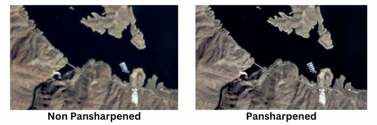
Benefits of pansharpening
Pansharpening technology significantly enhances the ability to detect small details in urban environments, particularly buildings, streets, and infrastructure. These details may be unclear in lower-resolution images.
Moreover, object detection algorithms and automatic image analysis techniques perform more effectively on pansharpened images. This makes pansharpening a crucial tool in:
- Urban Planning: Supporting land use mapping, population growth trends, and changes in land cover.
- Environmental Monitoring: Improving the ability to track urban fluctuations and human impacts on the environment.
- Decision Support: Providing high-quality data for GIS applications, remote sensing, and resource management.
Multispectral images have low spatial resolution, while panchromatic images have low spectral resolution. Neither dataset alone meets the requirements of applications that demand both high spatial and spectral resolution simultaneously. However, pansharpened images combine the advantages of both: they offer high spatial resolution while preserving detailed spectral information.
Pansharpening is a critical initial step in extracting geographic spatial information with high accuracy. In the past, accessing satellite imagery and large-scale analysis algorithms faced many challenges. However, this is gradually changing. Thanks to advances in satellite data and sophisticated processing algorithms, pansharpening is now more accessible through platforms like GEOHUB.
FAQs
Differences between panchromatic and multispectral images?
In the field of remote sensing, satellite images are primarily classified into two types: panchromatic images and multispectral images. The distinction between them lies in their spectral range and spatial resolution:
- Panchromatic Images: These are grayscale images that capture data over a broad spectral band, typically covering the entire visible range and sometimes extending into the near-infrared. Because they utilize a wide spectral band, panchromatic images generally have higher spatial resolution, enabling the clear depiction of Earth’s surface details.
- Multispectral Images: These capture data across multiple narrow spectral bands that cover specific portions of the electromagnetic spectrum such as the visible, near-infrared, and shortwave infrared regions. Each spectral band provides information about different physical and chemical properties of the surface, useful for classifying vegetation, soil, and water. However, due to capturing multiple spectral bands, multispectral images typically have lower spatial resolution compared to panchromatic images.
Earth observation satellites such as Landsat, SPOT, and Pléiades acquire both multispectral and panchromatic images, facilitating the application of pansharpening techniques that combine the advantages of both image types.
How to sharpen Sentinel-2 images when panchromatic band is absent?
The Sentinel-2 satellite does not provide a panchromatic band, which poses a challenge for enhancing the spatial resolution of multispectral images using traditional pansharpening techniques. To overcome this, a synthetic panchromatic band can be created by combining 10-meter resolution bands such as red, green, blue, and near-infrared. A common approach is to calculate the average or apply weighted algorithms to generate this synthetic band, which is then used in the pansharpening process to improve the spatial resolution of the multispectral image.
What to do when the spatial resolution of the panchromatic band does not meet requirements?
In cases where the spatial resolution of the panchromatic band is insufficient for a specific application, integrating data from different satellite sensors can be a solution. For example, Landsat 8 multispectral images have a spatial resolution of 30 meters, which can be enhanced to 15 meters when combined with its own panchromatic band. However, by using Sentinel-2 images for sharpening, a spatial resolution of 10 meters can be achieved, significantly improving image detail.
Additionally, deep learning super-resolution techniques are being researched and applied to enhance the spatial resolution of multispectral images beyond the limitations of existing panchromatic bands. These methods utilize machine learning models to predict and reconstruct spatial details, thereby improving the quality and accuracy of satellite image analysis.
Why is it not possible to simultaneously acquire images with both high spatial and high spectral resolution?
In the field of remote sensing, simultaneously acquiring images with both high spatial resolution and high spectral resolution faces technical and sensor design limitations. This trade-off primarily arises from two key factors:
Signal-to-Noise Ratio (SNR):
Satellite optical sensors are engineered with a specific signal-to-noise ratio to ensure the quality of acquired imagery. To enhance the detection energy, sensors may either:
- Broaden the spectral collection range by increasing the spectral bandwidth, which results in reduced spectral resolution.
- Increase the pixel size, thereby expanding the spatial coverage per pixel, which leads to reduced spatial resolution.
Consequently, enhancing one factor—either spatial resolution or spectral resolution—typically results in the degradation of the other. This outcome reflects the necessity to maintain the SNR at an acceptable level to guarantee data quality.
Data Volume Constraints:
High spatial resolution multispectral imaging generates a significantly larger volume of data. This poses challenges for data storage and transmission due to increased bandwidth and storage capacity requirements. Therefore, remote sensing system designers must balance the need for detailed data acquisition with the limitations of data processing, storage, and transmission capabilities, leading to an inherent trade-off between spatial and spectral resolution.
Interested in learning more about pansharpening and how to apply this technique to enhance your satellite imagery quality?
Please fill out the registration form to receive in-depth advice, our team of geospatial technology experts will get in touch with you to provide personalized consultation and solutions tailored to your remote sensing needs.