In the field of surveying and mapping, choosing between LiDAR vs. photogrammetry is rarely a straightforward decision. Whether you’re a beginner or a seasoned professional, the question of “which technology is more optimal?” remains a subject of ongoing debate. Both technologies enable the generation of 3D data for a wide range of applications, from terrain modeling and urban monitoring to forest management.
However, each method comes with its own strengths and limitations, making the decision not solely dependent on accuracy, but also on factors such as cost, time, terrain conditions, and intended use. In this article, we will delve into the technical and practical aspects of both LiDAR and photogrammetry to help you make the right choice for your project. Let’s explore together.
What is LiDAR and how does it work?
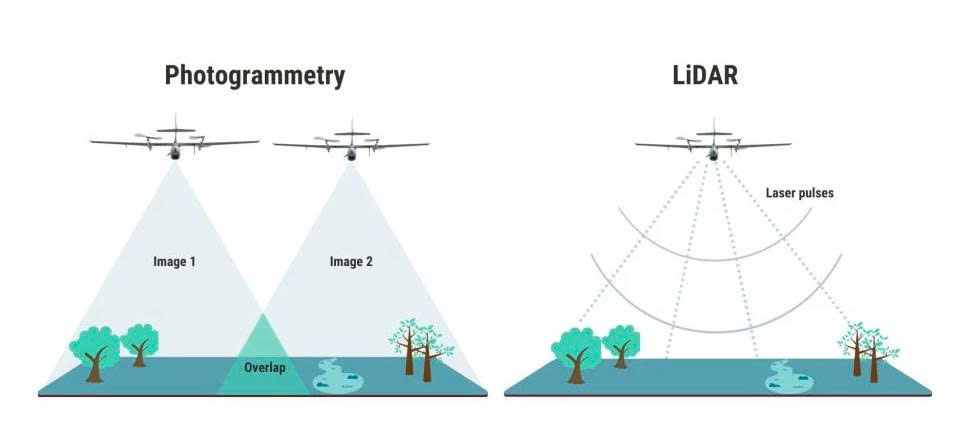
LiDAR – short for Light Detection and Ranging – is an active remote sensing technology that has become indispensable in 3D spatial modeling and surveying applications. Known for its ability to rapidly capture high-precision data across various environmental conditions, LiDAR is widely used in fields ranging from urban planning to natural resource management. Unlike passive data acquisition methods such as photography, LiDAR actively emits laser pulses toward a target surface, records the reflected signals, and calculates distances based on the time it takes for the light to return. This process enables the generation of highly detailed 3D models of terrain and surface features.
A reliable LiDAR system integrates multiple synchronized components, including a laser sensor, high-precision Global Navigation Satellite System (GNSS), and an Inertial Measurement Unit (IMU). This coordination ensures accurate tracking of the device’s position, orientation, and movement in three-dimensional space. As a result, LiDAR not only delivers raw spatial data but also supports centimeter-level accuracy in geospatial analysis, an essential capability in industries where terrain data reliability is critical.
What is photogrammetry and how does it work?
Photogrammetry is a technique that captures and analyzes images to reconstruct three-dimensional spaces from two-dimensional photographs. Unlike LiDAR, which actively scans surfaces using laser pulses, photogrammetry operates as a passive method, it collects data from natural light reflected off objects. When multiple images of the same subject are taken from different angles, specialized software identifies common points across the photos and stitches them together to create a complete 3D model.
The accuracy of this method depends on image quality, spatial coverage, and the system’s ability to correct for variations in camera angles, lighting conditions, or lens distortion. Leveraging advanced image processing algorithms, photogrammetry can faithfully reproduce not only the shape but also the color and surface texture of objects. From raw imagery, the process can generate orthomosaics, digital surface models (DSM), or high-resolution panoramic 3D models. As a result, photogrammetry is widely applied in building condition surveys, construction, precision agriculture, and cultural heritage preservation.
LiDAR vs. Photogrammetry: Which is the optimal choice for spatial mapping?
When it comes to recreating the real world in three dimensions, LiDAR and photogrammetry stand out as two leading technologies, each with its own unique approach. LiDAR excels in rapid data acquisition, penetrating dense vegetation, and generating highly accurate terrain models, even under low-light conditions. In contrast, photogrammetry is known for its high visual realism, lower cost of implementation, and ability to capture detailed surface colors and textures.
To help clarify the distinction, the comparison below outlines the key differences between LiDAR and photogrammetry, providing insights to guide you toward the most suitable technology for your project needs.
Comparison between LiDAR vs. Photogrammetry
|
Criteria |
LiDAR |
Photogrammetry |
|
Resolution |
Produces dense point clouds (50–200 pts/m², UAV-based). |
Lower point density (5–20 pts/m²). Resolution depends on Ground Sampling Distance (GSD), typically 2–5 cm. |
|
GSD (Ground Sampling Distance) |
Not directly applicable but can be estimated from point density. |
Primary resolution indicator: the lower the GSD, the higher the image resolution. |
|
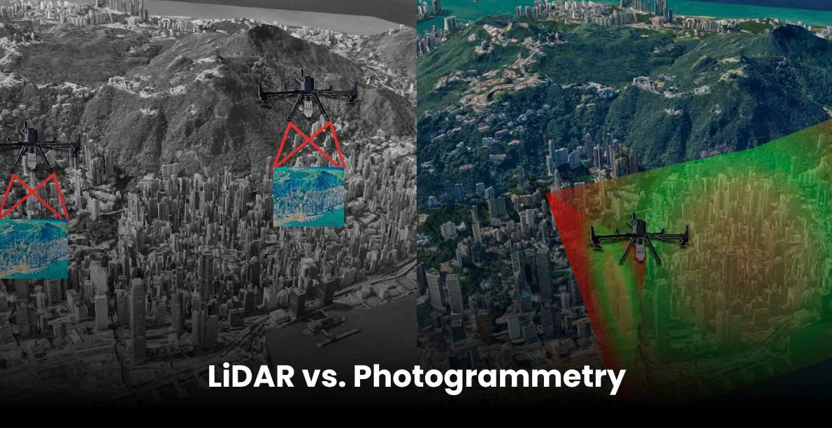
Coverage |
More efficient for large-area surveys, covering up to 10 km² per flight (fixed-wing drones). |
Limited by a narrower camera field of view, requires multiple images and complex stitching. |
|
Leaf Penetration |
Capable of detecting ground through gaps in canopy using laser pulses. |
Limited in dense vegetation due to shadows and lack of visibility through the canopy. |
|
Data Acquisition Speed |
Fast collection of millions of points per second with only 20–30% flight line overlap. |
Requires 60–90% overlap, which slows down acquisition for large or complex areas. |
|
Data Processing Time |
Fast processing due to direct distance measurement; mainly noise filtering and point classification. |
Time-consuming 3D reconstruction from overlapping images; needs powerful computing resources. |
|
3D Data Output |
Point clouds (LAS, E57), meshes (OBJ, STL, PLY), and interpolated grids (GeoTIFF, ASCII). |
3D models (OBJ, FBX), orthomosaics (TIFF, JPEG), and DEMs (GeoTIFF, ASCII). |
|
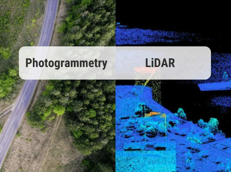
Texture & Color |
No inherent color; textures need to be applied using external imagery. |
Captures detailed textures and true colors directly from source images. |
|
Ease of Use |
Automated data acquisition, minimal manual intervention; requires technical knowledge for processing. |
Easier for beginners; uses familiar tools like drones and cameras, but requires careful planning for accurate results. |
|
Output File Formats |
LAS, E57, PTS (point cloud); OBJ, STL, PLY (meshes); GeoTIFF, ASCII (grids). |
OBJ, FBX, PLY (3D models); TIFF, JPEG (orthomosaics); GeoTIFF, ASCII (DEMs). |
Advantages and disadvantage of LiDAR technology
LiDAR is regarded as one of the most advanced technologies for collecting 3D spatial data, particularly recognized for its high measurement accuracy and effectiveness in complex environments. Its greatest strength lies in the ability to generate high-density point clouds, enabling the detailed reconstruction of terrain, even under dense vegetation or in challenging landscapes. As an active sensor that emits laser pulses, LiDAR can operate independently of ambient light, making it well-suited for nighttime surveys.
However, unlocking the full potential of LiDAR requires significant investment in both hardware and operational costs. Additionally, since LiDAR produces geometric data, its point clouds lack color and texture information, which limits its suitability for applications requiring high visual realism. Finally, processing and analyzing LiDAR data demands specialized skills, making it a powerful yet less beginner-friendly tool.
Strengths and drawbacks of photogrammetry
Photogrammetry has proven to be a cost-effective method for creating 3D models from images, taking advantage of widely available equipment such as digital cameras or drones equipped with commercial-grade cameras. One of its key strengths lies in its ability to capture environments with vivid color and detailed textures, making it particularly well-suited for visually oriented applications like heritage preservation, architectural modeling, or media production.
Another benefit is its flexibility in deployment, whether using drones or various camera systems, setups can be easily adapted to meet specific project needs. Moreover, learning to operate photogrammetry software is generally more accessible than LiDAR, allowing even beginners to produce high-quality 3D outputs.
That said, photogrammetry does face certain challenges. Its accuracy depends heavily on factors such as image quality, flight altitude, and capture conditions. Dense vegetation can obscure ground features, making data acquisition less reliable in such environments. Good lighting is also essential to ensure sharp imagery, and processing large datasets can be time-consuming.
Ultimately, selecting the right technology involves balancing accuracy requirements, visual output needs, and available budget. Photogrammetry is often the ideal solution when visually rich results are needed at a reasonable cost with moderate deployment complexity.
LiDAR vs. Photogrammetry: Which delivers greater accuracy?
In spatial surveying, both LiDAR and photogrammetry are capable of delivering accurate data, yet each technology offers distinct strengths depending on the context.
LiDAR stands out in terms of absolute accuracy, especially in complex terrains or areas with dense vegetation. Because it measures directly using laser pulses, systems like the JoLiDAR-1500 can achieve horizontal accuracy of approximately 1 cm and vertical accuracy of 2–3 cm, with point densities reaching up to 500 points per square meter. Additionally, LiDAR operates independently of ambient light and does not require ground control points (GCPs), making it highly efficient for large-scale surveys.
Photogrammetry, while typically less precise in absolute terms, can still provide high relative accuracy when executed properly. With suitable equipment and a well-planned flight path, photogrammetry can achieve horizontal accuracy close to 1 cm. However, its results are more susceptible to variations in lighting conditions, vegetation cover, and sensor quality. To ensure optimal accuracy, the integration of GCPs or positioning technologies such as RTK or PPK is often necessary.
Practical applications of LiDAR and photogrammetry
LiDAR – Superior in complex terrain and high-precision requirements
- Forested terrain mapping: LiDAR can penetrate dense canopy layers to produce accurate Digital Terrain Models (DTMs), supporting construction planning, land use monitoring, and environmental research.
- Power line management: Accurately identifies the clearance between trees and conductors, helping to prevent outages and ensure infrastructure safety.
- Forest monitoring and wildfire prevention: Enables analysis of biomass, assessment of wildfire risks, and landslide susceptibility through detailed canopy and terrain data.
- Floodplain mapping: Provides precise elevation models that aid hydrological simulations and enhance early warning systems for natural disasters.
- Mining operations: Supports volume calculations, terrain change tracking, design planning, and site safety management through consistent topographic analysis.
Photogrammetry – Effective for visual surveys and 3D modeling
- Construction and infrastructure: Utilizes UAV-mounted cameras for real-time imaging, enabling the creation of 3D models, progress monitoring, and accurate measurements.
- Surveying sparsely vegetated areas: A cost-effective method for generating high-resolution topographic maps in regions with minimal canopy coverage.
- Asset management and structural inspection: Captures detailed aerial imagery of rooftops, retaining walls, and transportation systems for condition assessment.
- Precision agriculture (additional): Uses multispectral imagery to analyze crop health, supporting optimized irrigation and fertilization strategies.
When to use LiDAR or photogrammetry?
The choice between LiDAR and photogrammetry depends on specific project requirements, including accuracy, terrain conditions, timeframe, budget, and desired output formats.
- Accuracy and level of detail
LiDAR excels in capturing detailed terrain data, even beneath dense forest canopies or in low-light conditions. It is ideal for applications requiring precise elevation measurements, terrain modeling, structural analysis, or volumetric calculations.
Photogrammetry offers rich visual detail with accurate color and texture, making it suitable for projects that prioritize visual models and surface data—such as construction monitoring, site modeling, or surveys of open, flat areas. - Budget and deployment time
LiDAR generally involves higher costs for equipment and data processing but provides fast and efficient data collection in complex or large-scale environments.
Photogrammetry is more budget-friendly and makes good use of commercial UAVs. However, for high-quality 3D modeling in complex scenarios, processing time may be longer. - Terrain and vegetation conditions
LiDAR performs well in steep, forested, or hard-to-reach terrain. Its ability to penetrate vegetation allows for the generation of accurate digital terrain models (DTMs) in dense environments.
Photogrammetry is more effective in flat, sparsely vegetated areas. In dense forests, it may miss ground details due to canopy obstruction. - Output format and intended use
LiDAR produces high-accuracy point clouds suited for volumetric analysis, technical assessments, and infrastructure design.
Photogrammetry generates realistic 3D models and color orthophotos, supporting site visualization, construction monitoring, and land management applications.
Can LiDAR and Photogrammetry be used together?
Absolutely, combining LiDAR and photogrammetry is not only possible but highly recommended for projects that demand both detailed terrain data and rich visual imagery. Each technology offers distinct strengths:
LiDAR delivers high-accuracy point cloud data with the ability to penetrate dense vegetation, capturing true ground surfaces even beneath tree canopies. Meanwhile, photogrammetry provides vivid color, surface texture, and easily interpretable orthographic models.
When integrated, these technologies complement each other, resulting in 3D models that are geometrically precise and visually rich. This synergy enables planners, engineers, and GIS professionals to access more complete datasets for diverse applications, including topographic mapping, environmental assessments, infrastructure design, and monitoring of urban or rural changes.
The combined use of LiDAR and photogrammetry is becoming a powerful trend, especially in projects with high demands for both accuracy and visualization quality.