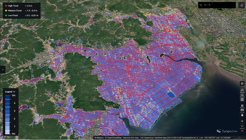
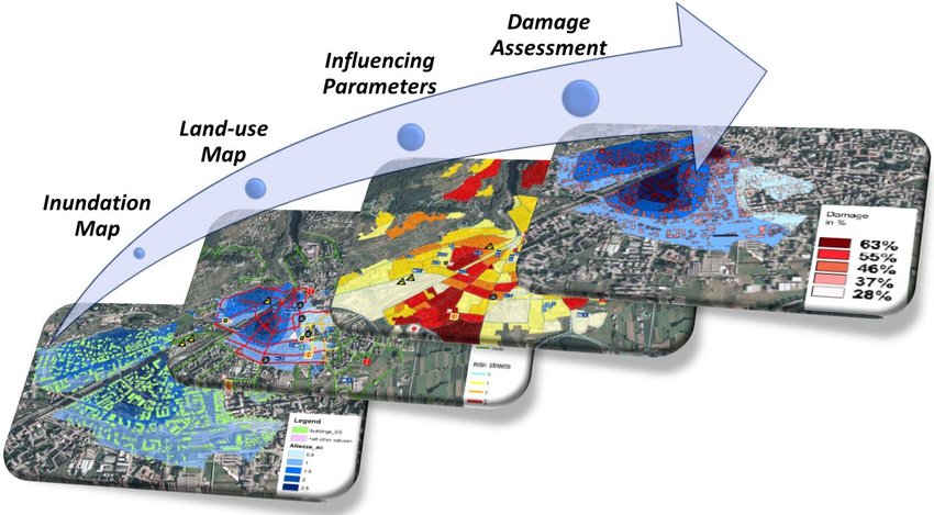
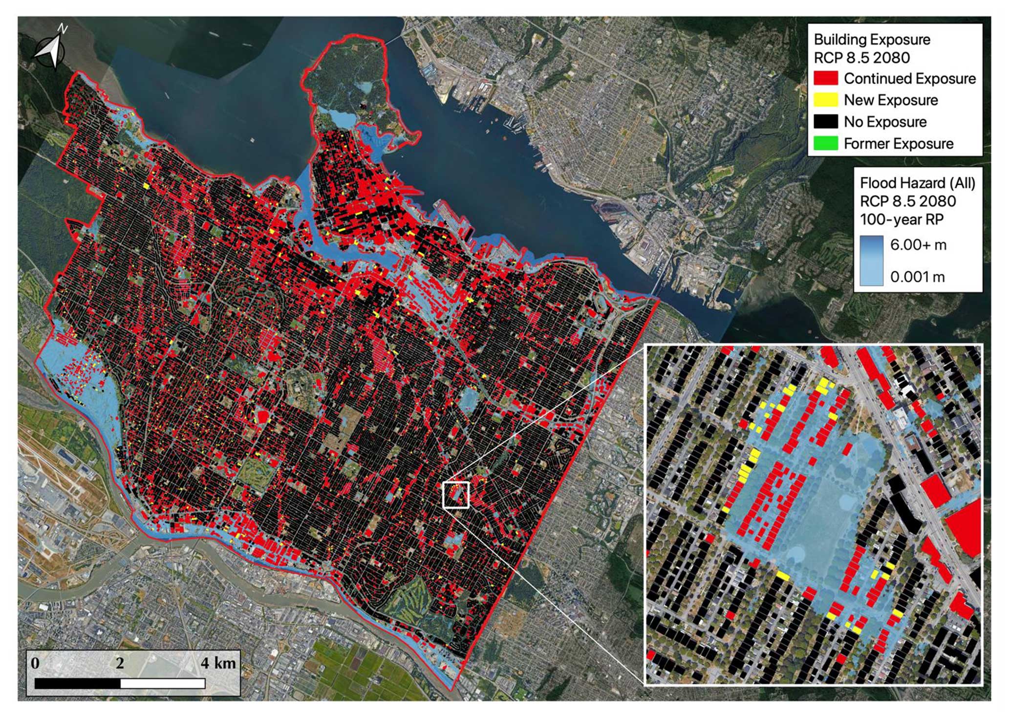
Climate change and rapid urban expansion are causing flood damage to strike more frequently and with greater intensity, creating an urgent demand for damage‑assessment methods that are both rapid and accurate. Thanks to its capability to image the Earth’s surface through clouds, heavy rain, and even at night, synthetic aperture radar (SAR) data, combined with digital elevation models, has become a critical foundation for this task.
The growing availability of SAR imagery, much of it freely provided by international space programs, enables the application of fuzzy logic, machine learning, and data‑fusion techniques to map flood extents, estimate water depth, and quantify losses at scale. This integration of radar technology with topographic information not only enhances emergency response effectiveness but also supplies a robust scientific basis for long‑term risk‑mitigation planning and climate‑adaptation strategies.
Flood Risk and the challenge of damage assessment
Flooding is one of the most widespread and devastating natural disasters, with its frequency and severity steadily increasing due to climate change, rapid urbanization, and land-use transformations. According to the United Nations and the World Bank, hundreds of millions of people are affected by floods each year, resulting in economic losses totaling tens of billions of USD. Beyond destroying homes, infrastructure, and crops, floods disrupt transportation systems, threaten access to clean water, increase the risk of disease outbreaks, and create long-term socioeconomic consequences.
However, one of the greatest challenges in flood management is the ability to rapidly and accurately assess the extent of damage. Before the widespread adoption of synthetic aperture radar (SAR) data, flood assessment primarily relied on ground-based observations, optical satellite or aerial imagery, and hydrological simulations. These methods have notable limitations: ground data is often delayed or incomplete in emergency situations; optical imagery is hindered by weather conditions and daylight availability, making it ineffective during heavy rain or cloud cover, precisely when floods are most active; while hydrodynamic models require extensive input data and significant computational time for calibration and execution.
As a result, prior to the use of SAR, flood extent mapping and damage estimation often lagged behind real-time needs, reducing the effectiveness of emergency response efforts and complicating resource allocation and recovery planning. The lack of timely and reliable information also left decision-makers reactive rather than proactive in risk assessment and long-term flood adaptation planning. The introduction and application of SAR technology have helped overcome many of these bottlenecks, thanks to its all-weather, day-and-night imaging capability and the consistent temporal coverage it provides.

Advantages of using SAR imagery for flood mapping
Synthetic Aperture Radar (SAR) uses microwave signals rather than visible light to capture images of the Earth’s surface, allowing it to function independently of sunlight and maintain reliable performance under heavy cloud cover, rainfall, or nighttime conditions. These characteristics make SAR a highly dependable tool for flood observation, especially in the context of accelerating climate change and increasingly extreme weather events.
All-weather observation capabilities
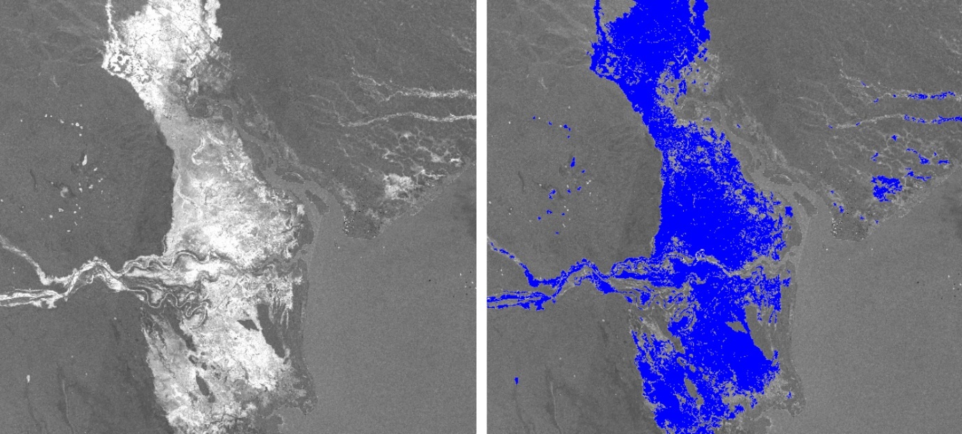
SAR’s ability to penetrate clouds, smoke, and rain ensures continuous data acquisition even during severe storms. For instance, during the historic floods in Central Vietnam in October 2020, prolonged heavy rainfall caused widespread inundation across provinces such as Quảng Bình, Thừa Thiên Huế, and Quảng Trị. Due to persistent cloud cover and adverse weather, optical satellite imagery could not provide timely information for damage assessment. In contrast, SAR data from the Sentinel-1 satellite proved highly effective, thanks to its all-weather imaging capabilities.
Pre- and post-flood SAR images accurately delineated flooded areas, enabling authorities to quickly assess the extent of damage, plan rescue operations, and allocate resources to the most affected regions. The use of SAR data significantly enhanced emergency response and post-flood recovery under complex and urgent conditions.
Flexible resolution for both urban and rural environments
Modern SAR satellites offer imagery with meter-level spatial resolution, capable of detecting flood boundaries along streets, high-rise buildings, and underground infrastructure in urban settings, while also accurately capturing inundation in farmlands, forests, and lowland rural areas. Unlike optical images, which may confuse dark water with shadows, SAR backscatter produces distinctive signal responses that help identify water boundaries and estimate water depth, even in complex terrain.
Time-series flood monitoring
Satellite constellations such as Sentinel-1 operate on fixed revisit cycles, capturing the same location every 6 to 12 days. This temporal consistency supports the construction of time-series datasets to monitor water progression or recession over time. Such insights are crucial for evacuation planning, emergency route access, and quantifying economic losses.
Penetration through sparse vegetation and surface water classification
SAR microwaves can penetrate thin vegetation canopies, enabling the detection of floodwaters beneath mangrove forests or riparian woodlands, areas where optical imagery often falls short. Furthermore, SAR backscatter analysis distinguishes between calm water bodies (lakes, ponds) and fast-flowing floodwaters, providing key information about flood dynamics and riverbank erosion risks.
Given these advantages, SAR data is increasingly leveraged in disaster response, environmental monitoring, and climate adaptation planning. However, the large volume and complexity of radar imagery require advanced processing technologies. Deep learning algorithms and data fusion techniques are playing a pivotal role in accelerating analysis and improving the accuracy of large-scale flood maps.

Advancements and emerging trends in flood mapping technologies
The adoption of deep learning in flood mapping has significantly improved both the accuracy and processing speed compared to traditional methods. However, deploying these technologies at scale, especially in real-time disaster warning and emergency response scenarios, remains a complex challenge. Addressing key limitations related to model performance, data timeliness and reliability, and integration with hydrological and hydraulic systems is currently the focus of extensive research and development efforts.
Real-time processing for early flood warning systems
Most deep learning models today are still primarily designed for post-disaster analysis, where SAR imagery is processed after a flood event to identify affected areas. However, for improved disaster response and mitigation, the ability to detect flooding as it occurs and issue timely warnings is a critical capability that demands further development.
Challenges in real-time flood mapping
– Computational complexity: Deep learning models typically require substantial computational resources, which can delay data processing—particularly when rapid response is needed.
– Limited real-time data: Most existing models rely on comparisons between pre- and post-flood satellite imagery. Real-time mapping, by contrast, requires predictive capability based on incoming data streams, without reference imagery for comparison.
– Data latency: Many satellites, including Sentinel-1, follow fixed orbital cycles and cannot provide continuous real-time imagery. This creates data gaps that hinder instant flood tracking.
Potential Solutions
– AI-powered streaming analysis: Deploying deep learning models on cloud platforms enables near-instantaneous processing of SAR data as soon as it is received, minimizing latency and improving real-time responsiveness.
– Edge computing: Running lightweight deep learning models directly on satellites or unmanned aerial vehicles allows for on-site flood detection without reliance on ground-based servers.
– Integration with IoT sensors: Combining SAR imagery with real-time water level data from river and urban drainage system sensors can enhance model accuracy and support faster, more informed emergency decision-making.

Generalizing models across diverse flood scenarios
One of the most significant challenges in applying deep learning to flood mapping lies in the ability of models to generalize effectively across regions with varying climatic and topographic conditions. Most current models are trained on datasets collected from specific locations, which often leads to reduced accuracy when applied to different geographic contexts. For example, a model trained on flood events in Europe may underperform when deployed in Southeast Asia or the Midwestern United States, where natural conditions and flood characteristics differ markedly.
Challenges in model generalization
– Topographic and hydrological variability: Elements such as slope, soil type, urban density, river networks, and regional climate significantly influence floodwater behavior. A model trained in flat, low-lying areas may not perform well in mountainous regions with complex drainage systems and rugged terrain.
– Variations in SAR image characteristics: Technical differences in SAR data, such as polarization, spatial resolution, and incidence angle, can vary across satellite missions or geographic regions, posing difficulties for models attempting to identify flood patterns in heterogeneous datasets.
– Seasonal factors and flood types: Floods triggered by tropical cyclones, tidal surges, or monsoonal rains differ in their spread rate, water depth, and duration. A model trained on monsoon flood data may fail to capture the dynamics of typhoon-induced flooding.
Potential Solutions
– Transfer learning: Instead of retraining entire models for each new region, transfer learning enables the reuse of previously learned features from original data and fine-tuning them with a small amount of local data—reducing training costs and improving model adaptability.
– Multimodal learning: Integrating SAR imagery with optical images, elevation models, terrain information, and meteorological data provides a more holistic understanding, enhancing model performance across diverse flood scenarios.
– Data augmentation: Generating synthetic flood scenarios across various environmental and climatic conditions allows models to learn a wider range of features, thereby increasing their capacity to detect floods in unfamiliar regions.

Quantifying uncertainty in flood forecasting
Most current flood mapping models produce binary outputs, classifying areas as either “flooded” or “not flooded” with absolute certainty. However, in reality, flooding is a dynamic phenomenon influenced by a wide range of unpredictable factors, making strict classifications an oversimplification. As a result, quantifying uncertainty in flood prediction has emerged as a key research direction to improve the reliability and real-world applicability of flood maps.
Challenges in quantifying uncertainty
– Sensor noise and image distortion: SAR data often suffer from speckle noise, terrain-induced distortions, and unwanted reflections from man-made surfaces, all of which can reduce the accuracy of flood extent detection.
– Ambiguity in water boundaries: Floodwaters typically do not follow clear-cut boundaries; they can gradually encroach on residential areas or recede slowly, creating transitional zones that are difficult to classify definitively as flooded or non-flooded.
– Inconsistent model performance: Deep learning models may perform well in some types of terrain but produce less reliable results in complex urban areas, where overlapping features like roads, buildings, and vegetation introduce classification ambiguity.
Potential solutions
– Bayesian neural networks (BNN): These models assign probability values to each prediction, enabling the explicit representation of confidence levels in flood classification. This information is especially valuable for decision-makers needing to weigh risks under uncertainty.
– Deep gaussian processes: This technique generates continuous probabilistic estimates for every spatial point, allowing for the simulation of flood extents under multiple scenarios, which supports more flexible and robust emergency planning.
– Ensemble modeling: By aggregating results from multiple deep learning models and averaging predictions, this approach reduces bias and yields flood maps with higher reliability while explicitly indicating regions of uncertainty.
Integration with hydrodynamic models
Hydrodynamic models are built on physical principles to simulate water flow and flood propagation across landscapes, factoring in rainfall, river discharge, soil infiltration, and topography. In contrast, deep learning models excel at recognizing spatial patterns from satellite imagery but lack an intrinsic understanding of the physical laws governing flood behavior. Therefore, combining deep learning with hydrodynamic models presents a promising approach to improving flood mapping and forecasting performance.
Challenges in integrating deep learning with hydrodynamic models
– Lack of physical constraints: Most deep learning models are trained on historical data without incorporating hydrological principles, which can lead to predictions that defy physical reality.
– High computational cost: Traditional hydrodynamic simulations require significant computational resources, especially when applied over large areas or at high resolutions, making real-time deployment challenging.
– Dependence on detailed input data: Accurate hydrodynamic modeling relies on comprehensive environmental data such as rainfall intensity, river discharge, soil moisture, and terrain structure, which are not always readily available or updated in time.
Potential solutions
– Physics-informed machine learning: This approach embeds physical constraints (e.g., Navier-Stokes equations) directly into deep learning models to generate predictions that are both accurate and physically plausible.
– Hybrid AI-physics models: A combined model structure leverages the strengths of both methods, using deep learning for rapid flood detection and hydrodynamic models for more precise long-term flood evolution simulations.
– Surrogate models: Rather than running complex physical simulations each time, surrogate models are trained on precomputed hydrodynamic scenarios, enabling much faster forecasts while maintaining physical realism.
In the context of increasingly complex and unpredictable natural disasters, the application of Synthetic Aperture Radar (SAR) data has opened a new, efficient, and flexible path for flood damage assessment. With its ability to operate under all weather conditions, observe Earth’s surface in detail, and support time-series monitoring, SAR data not only enhances flood mapping accuracy but also plays a crucial role in providing timely information for emergency response, resource allocation, and post-disaster recovery planning. When integrated with technologies such as deep learning, IoT sensors, and hydrodynamic modeling, SAR is poised to remain a key enabler in building early warning systems and strengthening flood risk management in the future.
