LiDAR vs. RADAR are two essential sensing technologies that play a pivotal role across various domains such as intelligent transportation systems, aerospace, remote sensing, and weather monitoring. Each technology possesses distinct characteristics in terms of operating principles, measurement accuracy, detection range, performance under varying weather conditions, and implementation costs. This article provides an in-depth comparison between LiDAR and RADAR to offer a comprehensive understanding, enabling readers to make informed decisions and select the most suitable solution for their specific application needs.
What is LiDAR and how does it work?
LiDAR (Light Detection and Ranging) is a spatial measurement technology that uses light in the form of laser pulses to determine distances to objects. The system operates on the principle of emitting laser pulses and measuring the time it takes for the pulses to reflect back after hitting a surface. This reflection time is then used to calculate the distance to the object using the Time of Flight (ToF) method, which assumes the speed of light is constant.
A standard LiDAR system consists of three main components: a laser emitter, a scanner, and a signal receiver (detector). The laser source generates intermittent pulses of light that are scanned across the target area using rotating mirrors or micro-electromechanical systems (MEMS). After reflecting off a surface, the light pulses are captured by the detector to compute the spatial position of each reflected point.
Thanks to its ability to deliver highly detailed and high-resolution data, LiDAR is widely used in 3D mapping, terrain modeling, digital twin creation of environments, and a wide range of research and management applications.
What is RADAR and how does it work?
RADAR (Radio Detection and Ranging) is a sensing technology that uses radio waves to determine the distance, azimuth angle, or velocity of objects. The system operates on the principle of transmitting electromagnetic waves in the radio frequency range and receiving the reflected signals (echoes) from target objects. By measuring the time it takes for the signal to travel to the object and return, the system can calculate the object’s location and motion characteristics.
A typical RADAR system consists of three main components: a transmitter, an antenna, and a receiver. The transmitter generates radio waves, which are emitted into the environment through the antenna. When these waves encounter an object, they reflect back and are captured again by the antenna. The returning signals are then processed by the receiver to extract information such as distance, velocity, and direction of the detected object.
Thanks to its ability to operate effectively in harsh weather conditions and at night, RADAR is widely used in aviation, maritime navigation, weather monitoring, autonomous guidance systems, remote sensing, and geophysical research.
Which has a shorter wavelength – LiDAR vs. RADAR?
LiDAR uses light waves, typically with wavelengths ranging from 700 to 1550 nanometers, which are much shorter than RADAR waves, which range from 0.3 to 100 centimeters.
Differences and similarities between LiDAR and RADAR
Wavelengths and electromagnetic wave principles
One of the fundamental distinctions between LiDAR and RADAR lies in the type of electromagnetic waves each system uses to capture information. LiDAR operates using laser light, typically in the near-infrared (NIR) spectrum, with short wavelengths that enable the acquisition of highly detailed data. In contrast, RADAR uses radio or microwave signals, which have significantly longer wavelengths, allowing for more stable signal transmission in complex environmental conditions and over long distances.
LiDAR measures the distance to an object by calculating the time it takes for laser pulses to reflect back to the sensor, a highly accurate method, though it depends on the reflectivity of the surface and atmospheric conditions. Thanks to its rapid pulse emission and reception rate, as well as its ability to continuously scan space, LiDAR can generate dense point clouds that are ideal for 3D mapping and detailed surface modeling applications.
Meanwhile, RADAR systems, especially those mounted on aircraft or satellites, can survey large areas in a short amount of time. RADAR’s data acquisition capability depends on its transmission frequency and the speed of the sensing platform. While it does not produce spatial detail as dense as LiDAR, RADAR provides consistent and reliable information under a wide range of environmental conditions. This makes it particularly valuable for weather monitoring, motion tracking, and defense-related applications.
Accuracy and resolution
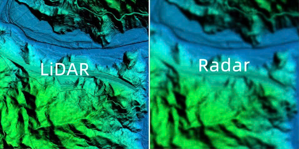
LiDAR stands out for its ability to deliver high-resolution spatial data with exceptional accuracy. By emitting millions of laser pulses per second and measuring the return time of each pulse, LiDAR generates extremely detailed 3D point clouds that can accurately reconstruct the shape and position of terrain surfaces or man-made structures. In many cases, LiDAR systems can achieve accuracy levels within a few centimeters, meeting the stringent demands of surveying, construction, mapping, and various engineering applications.
In contrast, RADAR utilizes radio waves with longer wavelengths, which typically results in spatial data with lower resolution. Although RADAR can still measure object distance and velocity with high accuracy, making it especially effective for motion tracking applications, its lower geometric detail makes it less suitable for scenarios requiring finely detailed surface modeling. The typical positional accuracy of RADAR ranges from several tens of centimeters to a few meters, which is significantly lower than that of LiDAR.
Long-range detection capability
LiDAR generally performs most effectively in short- to medium-range applications. As it relies on laser light, its operational range is limited by atmospheric signal attenuation and environmental conditions. In practice, most commercial LiDAR systems operate within a range of several hundred meters to a few kilometers. Although long-range LiDAR units do exist, they are typically more expensive and energy-intensive, making them less commonly used. Thanks to its high precision at close range, LiDAR is well suited for applications such as autonomous vehicle navigation, infrastructure surveying, forest monitoring, and urban environmental research.
In contrast, RADAR excels in detecting objects over long distances. Utilizing radio waves that propagate efficiently and are less affected by fog, rain, or dust, RADAR systems can monitor targets tens or even hundreds of kilometers away. This makes RADAR the preferred choice for tasks such as air traffic control, maritime surveillance, long-range weather forecasting, and large-scale military reconnaissance operations.
Velocity detection and measurement capability
LiDAR is primarily designed to capture high-precision 3D spatial data, focusing on measuring distances from the sensor to surrounding objects. However, because it operates using infrared light and does not leverage the Doppler effect, LiDAR cannot directly measure object velocity. Some advanced systems can estimate speed by analyzing a sequence of consecutive measurements over time, but these estimates tend to be less accurate than those obtained from technologies specifically designed for motion detection.
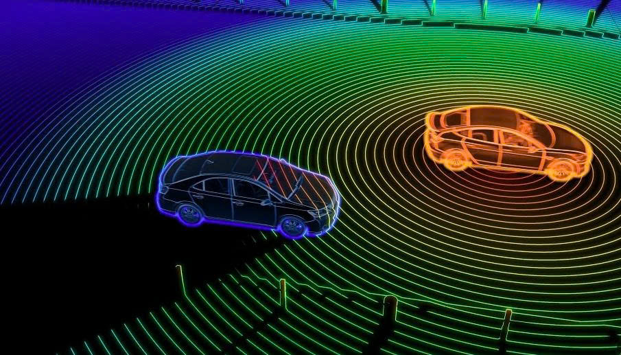
In contrast, RADAR excels at velocity measurement thanks to its use of the Doppler effect, the change in frequency of reflected waves caused by a moving object. Doppler radar can accurately determine the relative speed between the sensor and its target, even at long distances or high velocities. This capability is essential in various domains, including traffic monitoring, airspace surveillance, weather forecasting, and military operations.
Reliability and environmental adaptability
Because LiDAR operates using laser light, its performance is highly sensitive to atmospheric conditions such as fog, heavy rain, or snow. Small airborne particles can scatter or absorb the laser pulses, weakening the return signal and significantly affecting data accuracy. In dense fog, signal attenuation can be substantial, reducing both the effective range and the reliability of measurements, particularly in outdoor applications that demand consistent performance.
In contrast, RADAR uses radio waves with much longer wavelengths than light, enabling it to penetrate adverse weather conditions like rain, snow, or fog with minimal signal degradation. This physical advantage allows RADAR systems to maintain operational effectiveness in complex environmental conditions, delivering stable and continuous data. Such reliability is crucial in applications requiring high operational uptime, including air traffic control, maritime navigation, and large-scale weather monitoring and warning systems.
Investment cost and system complexity
LiDAR systems generally require a higher initial investment due to their complex architecture and reliance on high-precision components. Integrating powerful laser sources, mechanical scanners such as rotating mirrors or opto-mechanical systems, along with sensitive detectors and high-speed data processing platforms, significantly increases both production and operational costs. Furthermore, the large volume of high-resolution data collected by LiDAR demands robust storage capacity and specialized data processing tools, adding to infrastructure and analytical expenses. Additionally, due to their susceptibility to environmental factors, LiDAR systems often require regular calibration and technical maintenance to ensure measurement accuracy.
Conversely, RADAR is considered a more cost-effective solution, featuring a simpler technical configuration. The system typically consists of a radio wave transmitter, receiver, and antenna, components that are generally cheaper to produce and easier to deploy compared to LiDAR’s high-tech optical elements. Unlike LiDAR, RADAR does not require moving mechanical parts for beam steering, as it can electronically direct its signal, thereby reducing mechanical complexity. Moreover, thanks to its stable performance across diverse weather conditions, RADAR systems demand less frequent maintenance and calibration, which contributes to lower long-term operational costs.
Differences in system architecture and operating mechanisms
LiDAR and RADAR differ significantly in both structural design and signal processing mechanisms. LiDAR systems, whether ground-based or airborne, typically integrate imaging sensors or digital cameras to capture the reflected light from emitted laser pulses. The returned signals are then processed into three-dimensional point clouds, enabling the creation of highly detailed spatial models. This makes LiDAR especially suitable for applications such as terrain mapping, infrastructure surveys, and urban modeling.
In contrast, RADAR systems rely on the reflection of radio waves, converting the returned signals into visual representations on radar displays or computational outputs. Due to their longer wavelengths and differing energy reflection mechanisms, RADAR systems do not offer the same level of distance accuracy at close range as LiDAR. However, they excel at detecting objects at longer ranges and in adverse environmental conditions.
Regarding operational range, LiDAR is typically limited to short- to medium-distance applications and requires a clear line of sight, as laser signals are easily obstructed. RADAR, on the other hand, can function effectively at greater distances and is capable of penetrating obstacles such as fog, rain, or dust. Additionally, LiDAR systems tend to involve higher costs and more complex technical configurations, whereas RADAR systems are generally simpler to deploy and maintain, making them well-suited for wide-area or continuous monitoring applications.
Practical applications of LiDAR and RADAR
LiDAR applications
LiDAR vs. RADAR are engineered for distinct purposes, which is clearly reflected in their real-world applications. LiDAR is commonly used in mapping and surveying due to its ability to produce high-resolution 3D maps with exceptional spatial accuracy. This technology is particularly suited to applications requiring detailed surface and spatial structure analysis, such as autonomous vehicles, urban planning, archaeology, forest analysis, and cultural heritage preservation.
- Topographic Mapping: LiDAR has become a primary tool in terrain mapping. With the ability to rapidly capture high-resolution elevation data from airborne platforms, LiDAR enables the creation of detailed Digital Elevation Models (DEMs). These models are crucial for forestry, hydrology, urban planning, geomorphology, and coastal engineering. They provide valuable input for flood risk assessment, infrastructure design, and volumetric terrain analysis.
- Autonomous Vehicles: LiDAR sensors mounted on the roof or sides of autonomous vehicles emit laser pulses to measure distances based on the time-of-flight of reflected light. The collected data is integrated with GPS and camera inputs to create real-time 3D maps of the surrounding environment. This enables the vehicle to detect and avoid obstacles effectively, even in low-light or adverse weather conditions.
- Archaeology and Cultural Heritage: In archaeology, LiDAR offers a non-invasive surveying solution, generating high-resolution 3D maps of terrain and concealed man-made structures. This technology allows researchers to identify ancient settlements and hidden sites beneath dense vegetation without disturbing physical artifacts.
- Forestry and Vegetation Analysis: In forest management, LiDAR is used to estimate tree height, canopy density, and forest biomass. Its ability to penetrate the canopy and analyze vertical forest structure supports effective monitoring of forest health, resource planning, erosion or landslide risk assessment, and forest road design optimization.
RADAR applications
RADAR technology is widely adopted across multiple sectors due to its capability to detect, track, and measure the position and velocity of objects using radio waves. From traffic safety to national defense, RADAR plays a critical role in providing real-time data that supports precise and timely decision-making. Below are some of the most prominent applications of RADAR:
- Aviation Safety: RADAR serves as a core component of modern air traffic management systems. Ground-based RADAR stations track the position and altitude of aircraft, ensuring safe separation within controlled airspace. Meanwhile, airborne RADAR assists pilots in navigation and in avoiding hazardous weather phenomena. Advanced technologies such as Automatic Dependent Surveillance–Broadcast (ADS-B) allow aircraft to automatically transmit their position and flight information to ground stations, enhancing situational awareness for both pilots and air traffic controllers.
- Maritime Navigation: RADAR is vital to ensuring maritime safety, particularly in poor weather conditions or limited visibility. Onboard RADAR systems help vessels detect other ships, obstacles, and navigational aids such as buoys and lighthouses. This is especially crucial when operating in congested waterways or during port approach and departure.
- Weather Monitoring and Forecasting: Weather RADAR systems are indispensable in meteorology, enabling the detection and tracking of severe weather phenomena such as heavy rainfall, thunderstorms, and tornadoes. These systems provide real-time data on the location, intensity, and movement of weather systems, supporting early and accurate warnings that help minimize loss of life and property.
- Military and Defense: In defense applications, RADAR is extensively used for airspace surveillance, target detection and tracking, missile guidance, and air defense systems. Advanced technologies like Synthetic Aperture Radar (SAR) enable high-resolution imaging even under poor weather conditions or at night, significantly enhancing intelligence gathering and battlefield situational awareness.
- Automotive Safety Systems: RADAR is increasingly integrated into advanced driver-assistance systems (ADAS) in modern vehicles. It enables the detection of nearby vehicles, pedestrians, and obstacles, supporting safety features such as adaptive cruise control, automatic emergency braking, forward collision warning, and lane departure alert. The use of RADAR contributes to improved road safety, reduced accident risk, and advances in autonomous vehicle technology.

Why do these differences matter?
The differences in wavelength of LiDAR vs. RADAR technologies are not merely technical distinctions, they have profound implications for the quality, resolution, and applicability of the data collected. LiDAR, which operates using much shorter wavelengths in the near-infrared or visible light spectrum, is capable of producing high-resolution, highly detailed spatial data. This makes it especially effective at accurately capturing the shape, structure, and distance of objects at close to medium range.
However, LiDAR’s accuracy is influenced by more than just its use of laser light. It also depends on factors such as the quality of the laser source, the design and precision of the scanning mechanism, and environmental conditions like rain, fog, or airborne particulates. These factors can degrade signal strength and reduce data reliability under adverse weather.
In contrast, RADAR systems use longer-wavelength radio waves, which cannot achieve the same level of spatial detail as LiDAR. Nevertheless, this trade-off comes with distinct advantages: RADAR maintains reliable performance across a wide range of environmental conditions, including heavy rain, snow, and fog, and can operate effectively over much greater distances.
RADAR accuracy depends on factors such as operating frequency, antenna design, and signal processing capabilities. While precipitation can attenuate radar signals to some extent, RADAR still holds a significant advantage in terms of all-weather operation, lower deployment costs, and larger coverage areas. These characteristics make it ideal for applications where robustness and long-range capability are prioritized over fine spatial detail.
Which technology is right for your project: LiDAR vs. RADAR?
LiDAR offers exceptional spatial resolution and measurement accuracy, making it the ideal choice for applications that require detailed 3D mapping, such as topographic surveying, autonomous vehicle navigation, and infrastructure planning. However, its high cost and reliance on clear line-of-sight conditions can be significant limitations, particularly in large-scale or weather-sensitive environments.
On the other hand, RADAR excels in detecting moving objects over long distances and operates reliably in adverse weather conditions, including rain, fog, and snow. With generally lower deployment and maintenance costs, RADAR is widely used in aviation, maritime navigation, military surveillance, and automotive safety systems.
Ultimately, the choice between LiDAR and RADAR should be based on the specific technical objectives and environmental conditions of your project. If your priority is high-resolution spatial data and surface modeling, LiDAR may be the more appropriate solution. If you need robust, long-range performance under challenging conditions, RADAR provides a more cost-effective and resilient alternative.