LiDAR technology is increasingly becoming an indispensable tool across various fields, from topographic surveying and environmental research to autonomous vehicle development and digital mapping.
LiDAR, short for Light Detection and Ranging, is a remote sensing technology that uses laser pulses to measure distances from the sensor to surface targets, thereby reconstructing accurate 3D models of the Earth’s surface and surrounding objects.
A typical LiDAR system consists of a laser emitter, a scanner, and a GPS receiver, and is often mounted on aircraft or helicopters to collect data over large areas. Depending on the application, LiDAR is generally categorized into two main types: topographic LiDAR, which uses near-infrared laser light to map terrestrial surfaces, and bathymetric LiDAR, which employs green laser light to penetrate water and measure the elevation of seabeds, riverbeds, or submerged environments.
In this article, we’ll answer more than 15 of the most faq about LiDAR technology, helping you, whether you’re a beginner or simply curious, gain a clear, comprehensive, and accessible understanding of the technology that is transforming how we observe and analyze the world around us.
What is the resolution of LiDAR data?
The resolution of LiDAR data is commonly expressed through pulse density, the number of laser pulses emitted per square meter. For freely available datasets, pulse density typically ranges from 0.8 to 3 pulses per square meter (pulses/m²). In certain cases, when LiDAR sensors are mounted on aircraft flying at low altitudes (approximately 200–600 meters), the density can reach 10 pulses/m² or more.
In addition to pulse density, another important metric is return density (or point return density), the number of recorded reflections per square meter. Since a single laser pulse can generate multiple returns when it interacts with different surfaces (e.g., tree canopies, the ground), the return density is often higher than the pulse density.
With Terrestrial Laser Scanning (TLS) technology, data resolution can reach hundreds of pulses per square meter, thanks to the short-range scanning and high pulse repetition rate. This results in significantly higher detail compared to airborne LiDAR systems.
How is LiDAR data different from satellite imagery?
The fundamental difference between LiDAR data and satellite imagery lies in how the signals are acquired. Satellite imagery is a form of passive remote sensing, similar to a photograph taken under natural lighting conditions. Satellite sensors do not emit any signals; instead, they capture sunlight reflected off the Earth’s surface. As a result, image acquisition is entirely dependent on external lighting conditions, such as time of day or cloud cover.
In contrast, LiDAR is an active remote sensing technology. It emits laser pulses and records the signals reflected back from surfaces, allowing it to operate independently of ambient light—even at night or in low-light environments.
Furthermore, unlike satellite images, LiDAR data does not contain spectral information (such as color or reflected light wavelengths). Instead, it delivers highly detailed geometric information, including 3D spatial coordinates and the intensity of each laser return. This makes LiDAR exceptionally valuable for accurately mapping terrain surfaces and structural features.
Is LiDAR the same as laser scanning?
In essence, LiDAR and laser scanning are terms often used interchangeably, as both refer to the same underlying technology: using laser pulses to measure distances to surfaces and reconstructing spatial models in the form of 3D point clouds.
However, the terminology may vary depending on the context or industry. For instance, in the fields of mapping and remote sensing, the term LiDAR is more commonly used, while laser scanning tends to be favored in construction, architectural surveying, or civil engineering applications. Despite the difference in naming conventions, both terms describe the same fundamental operating principle.
Can LiDAR see through walls?
The answer is no. Standard LiDAR systems cannot penetrate solid objects such as walls, rooftops, or buildings. LiDAR operates by emitting laser pulses and measuring the time it takes for the reflected signals to return from surface objects. As a result, when the laser pulse hits a solid material, it reflects off the surface and cannot pass through to detect what lies behind it.
In scenarios where subsurface features need to be investigated, such as in geological or archaeological studies, a more suitable technology is Ground Penetrating Radar (GPR). GPR uses low-frequency radio waves that can penetrate certain materials like soil, ice, concrete, or thin walls to generate images of structures beneath the surface.
Can LiDAR penetrate the ground?
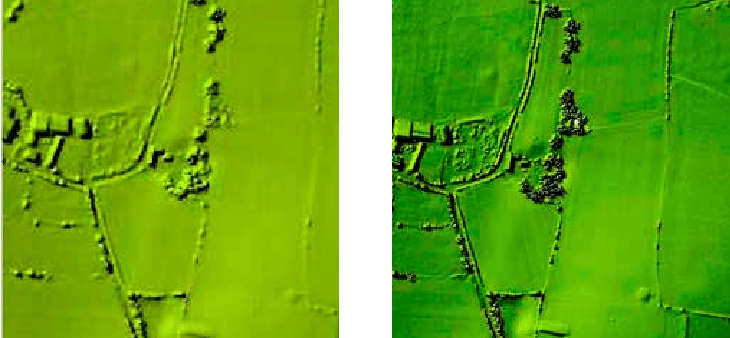
In principle, LiDAR cannot literally penetrate the ground in the way that ground-penetrating radar (GPR) can. However, one of LiDAR’s key strengths is its ability to penetrate through vegetation and loosely structured materials such as leaves, grass, branches, or surface debris. This capability enables the system to detect laser returns from the bare earth surface beneath forest canopies or complex terrain.
Thanks to this characteristic, LiDAR is an extremely valuable tool for generating Digital Terrain Models (DTMs) beneath forest cover, supporting applications in archaeology, forestry, and environmental planning. Nonetheless, the quality and depth of the data acquired depend on factors such as the density and type of surface cover, the sensor configuration, and flight parameters.
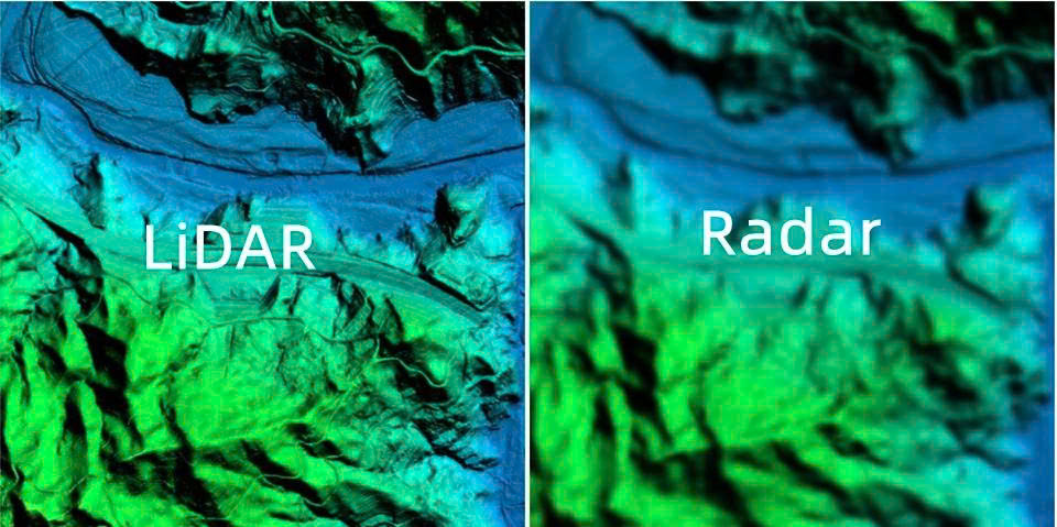
What is the difference between LiDAR and Radar?
LiDAR and RADAR are both remote sensing technologies that use electromagnetic waves to collect information about the distance and shape of objects. However, they differ significantly in terms of wavelengths, operational principles, and practical applications.
LiDAR (Light Detection and Ranging) uses laser pulses, typically operating in the visible or near-infrared spectrum, to measure distances based on the time-of-flight of the reflected signal. It is particularly known for its ability to generate high-resolution 3D models, making it ideal for topographic mapping, architectural surveys, forestry, and archaeological research.
Radar (Radio Detection and Ranging), on the other hand, uses radio waves, which have much longer wavelengths, to detect and measure the distance to objects. Due to these longer wavelengths, radar can penetrate through fog, rain, vegetation, or shallow ground layers, making it essential in weather forecasting, aviation, maritime navigation, military surveillance, and advanced driver-assistance systems (ADAS).
How is LiDAR used in autonomous vehicles?
In autonomous driving systems, LiDAR serves as a core sensor, enabling vehicles to perceive and interact with their surroundings. By emitting millions of laser pulses per second and recording the reflected signals, LiDAR generates real-time, high-resolution 3D maps that accurately capture the position of obstacles, lane markings, pedestrians, and other vehicles.
This capability allows self-driving cars to precisely measure distances to surrounding objects, helping the navigation system make safe and informed decisions in complex traffic scenarios, including low-light conditions where traditional optical sensors may struggle.
As a result, LiDAR plays a vital role in enhancing the stability, reliability, and safety of autonomous vehicles on the road.
What is the difference between 2D and 3D LiDAR?
The key difference between 2D and 3D LiDAR lies in their spatial data acquisition capabilities.
2D LiDAR scans in a single plane, typically in a horizontal or vertical direction. It provides distance information to objects within that plane but lacks data on height or depth. As a result, it cannot generate a full spatial representation. 2D LiDAR is commonly used in simple applications such as mobile robots, obstacle detection, or factory safety systems, where basic environmental awareness is sufficient.
3D LiDAR, on the other hand, captures data in multiple directions across three dimensions, producing detailed 3D point clouds that represent the width, height, and depth of the environment. This technology enables high-accuracy reconstruction of terrain, objects, and surrounding structures. As such, it is widely used in autonomous vehicles, topographic mapping, urban modeling, construction surveying, and scientific research.
Is LiDAR affected by weather conditions?
Yes. Although LiDAR is an active remote sensing technology capable of operating both day and night, its performance can be affected by adverse weather conditions. Phenomena such as heavy rain, dense fog, or snowfall can scatter, absorb, or deflect laser pulses, reducing the system’s accuracy in measuring distances and detecting objects.
In particular, in environments with a high concentration of airborne particles, such as water droplets or ice crystals, a portion of the laser signal may be reflected or attenuated before it reaches the target surface. This can introduce noise or lower the quality of the collected data.
However, the degree of impact depends on several factors, including sensor configuration, laser wavelength, and signal processing algorithms. As a result, many modern LiDAR systems are designed to maintain acceptable performance levels even under less-than-ideal weather conditions.
Are there any privacy concerns related to LiDAR?
In certain contexts, the use of LiDAR to collect high-resolution spatial data can raise privacy concerns, particularly when applied in areas such as residential surveillance, private property mapping, or data acquisition in personal spaces.
However, compared to technologies like optical cameras, LiDAR is generally considered to be less intrusive. LiDAR primarily generates point cloud data, which represents the shape and location of objects without capturing visual details such as color, license plates, or human facial features. As a result, the potential for personally identifiable information to be derived from LiDAR data is minimal.
Nevertheless, in sensitive applications, it is essential to implement transparent data collection practices, comply with legal regulations and ethical standards, and ensure community trust and consent to safeguard privacy and promote responsible use of the technology.
Can LiDAR operate at night?
Yes. One of the key advantages of LiDAR is its ability to function independently of natural light, as it emits its own light source in the form of laser pulses. This enables the system to collect accurate data both during the day and at night, making it particularly valuable in applications that require continuous operation, such as autonomous vehicles, security surveillance, construction site monitoring, or mapping in low-light conditions.
How is LiDAR useful in archaeological research?
In archaeology, LiDAR has emerged as a groundbreaking tool due to its ability to penetrate dense vegetation and accurately capture the underlying terrain. This technology enables archaeologists to map ancient landscapes, uncover buried structures, and identify potential archaeological sites that are often invisible to the naked eye or traditional aerial imagery, especially in heavily forested or mountainous regions.
The use of LiDAR significantly reduces the time and cost of field surveys while minimizing physical disturbance to sensitive excavation sites, thus supporting the preservation of valuable historical remains.
Is LiDAR a part of GIS?
While LiDAR is not a structural component of a Geographic Information System (GIS), LiDAR data plays a vital role in enhancing and enriching GIS datasets. Thanks to its ability to capture highly accurate elevation and geometric information, LiDAR serves as a valuable input for generating terrain layers, digital elevation models (DEMs/DSMs), and infrastructure features within GIS platforms.
From LiDAR point cloud data, users can extract and construct various GIS layers such as building footprints, piers, breakwaters, port structures, and other architectural features. For example, the shape of a dock can be digitized from LiDAR data and integrated into a shaded terrain map to improve spatial accuracy and analytical value.
As a result, LiDAR is increasingly recognized as an essential data source in modern GIS applications, particularly in urban planning, infrastructure management, and 3D spatial modeling.
Is LiDAR a passive or active remote sensing technology?
LiDAR is an active remote sensing technology. This means the system emits its own laser pulses to scan the surrounding environment, then measures the return time of the reflected signals to determine the distance to target surfaces.
When integrated with high-precision GPS data and information about the device’s orientation (attitude), LiDAR can generate highly detailed and accurate elevation models across a wide range of terrains and surfaces, from urban landscapes to dense forests or complex topographies.
Unlike passive remote sensing systems, which rely on natural light or thermal radiation emitted by objects, LiDAR operates independently of ambient light conditions, enabling effective data acquisition both during the day and at night.
Can LiDAR detect humans?
Yes. LiDAR sensors are fully capable of detecting and tracking humans in real-world environments. By emitting thousands to millions of laser pulses per second and recording their reflections, LiDAR creates detailed 3D maps of the surrounding space, including moving objects.
By analyzing the shape, size, movement, and relative position of points within the point cloud, the system can identify the presence of people, making it especially effective in applications such as autonomous vehicles, mobile robots, surveillance systems, and behavioral analysis in public spaces.
However, to accurately distinguish humans from other objects, LiDAR is often combined with machine learning algorithms or data from complementary sensors like cameras or radar, which enhances both recognition accuracy and system reliability.
How does LiDAR measure distance?
LiDAR operates based on the Time of Flight (TOF) principle. During scanning, the system emits laser pulses from a transmitter, which then hit and reflect off surfaces in the surrounding environment.
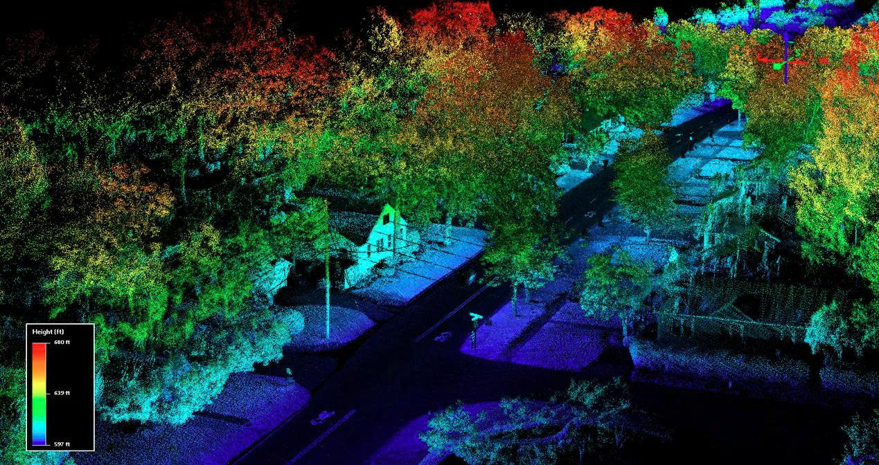
A receiver detects the time it takes for each reflected pulse to return. By using the speed of light, the system calculates the exact distance from the sensor to each object. By performing millions of such measurements in a short period, LiDAR constructs a detailed 3D map of the environment, commonly known as a point cloud.
This method makes LiDAR an extremely effective tool for terrain mapping, object detection, and real-time navigation, especially in fields like topographic surveying, intelligent transportation, autonomous robotics, and civil engineering.
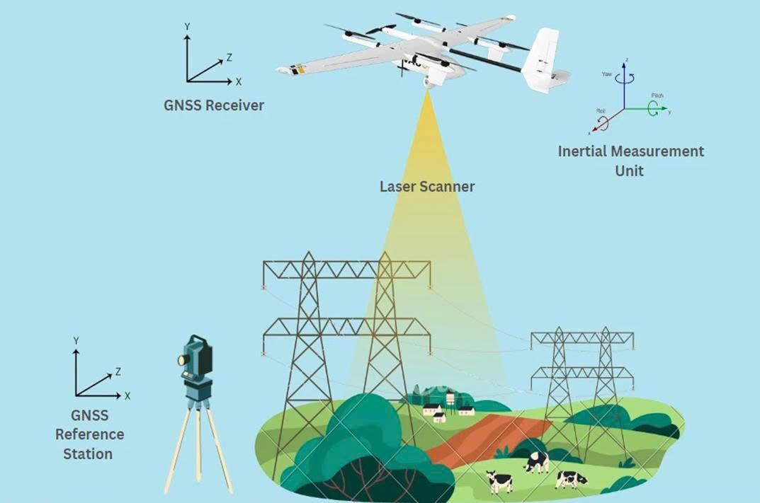
Does LiDAR require GPS?
Yes. GPS plays a crucial role in LiDAR systems, especially in airborne or mobile applications. A complete LiDAR setup typically includes a laser emitter, scanner, receiver, and, equally important, a high-precision GPS along with an Inertial Measurement Unit (IMU).
The GPS is used to determine the exact 3D position of the platform (such as an aircraft or UAV) at the moment each laser pulse is emitted. When combined with IMU data, which records motion and orientation, the system can assign precise coordinates to each point in the LiDAR point cloud, resulting in highly accurate spatial models.
With GPS integration, LiDAR becomes capable of mapping large areas with high geolocation accuracy, making it highly effective for applications such as topographic surveys, 3D mapping, resource management, and environmental monitoring.
What is the difference between a standalone LiDAR sensor and an integrated UAV LiDAR system?
A standalone LiDAR sensor is just one of several components required to collect accurate spatial data. In contrast, an integrated UAV LiDAR system is a complete solution designed to capture high-quality 3D data from the air using an unmanned aerial vehicle (UAV).
An integrated UAV LiDAR system typically includes:
- A LiDAR sensor for detecting and measuring the distance to surrounding objects;
- A GNSS/INS unit for accurately determining the UAV’s position and orientation in space;
- A data logger to store all collected information during flight;
- A wireless transmission module to enable real-time monitoring and sensor control from the ground;
Hardware synchronization between the LiDAR and GNSS/INS, ensuring timing accuracy to within milliseconds.
The precise coordination between these components is essential for generating high-accuracy point clouds, which is critical for applications such as topographic surveys, 3D mapping, forest management, and infrastructure monitoring.