Lưu trữ danh mục: News
Ứng dụng công nghệ viễn thám quang học giám sát ngập lụt do hoàn lưu bão Matmo (phần 1)
Bão số 11 (bão Matmo) đổ bộ tỉnh Quảng Tây (Trung Quốc), giáp khu vực [...]
Th10
Flood monitoring using SAR technology – Aftermath of Typhoon Bualoi, 2025
Typhoon Bualoi made landfall in Nghe An and Ha Tinh in the early morning of [...]
Th10
Giám sát ngập lụt do hoàn lưu bão Bualoi bằng công nghệ SAR (phần 1)
Bão Bualoi đổ bộ vào khu vực Nghệ An và Hà Tĩnh vào sáng sớm [...]
Th10
Assessing Flood Damage with SAR Data: Faster, Smarter, More Accurate
Climate change and rapid urban expansion are causing flood damage to strike more frequently and [...]
Th8

Geospatial Tech Trends 2025: What’s Transforming the Industry?
Geospatial tech trends are undergoing a powerful transformation, entering a new phase in which Earth-observation [...]
Th8

The Role of Satellite Imagery in Disaster Management and Recovery
Natural disasters are occurring with growing frequency and intensity, and humanity has yet to fully [...]
Th8
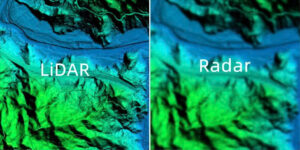
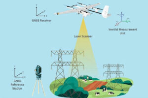
LiDAR vs. RADAR? How to Choose the Right Technology for Your Project
LiDAR vs. RADAR are two essential sensing technologies that play a pivotal role across various [...]
Th6

LiDAR Accuracy and Resolution: Do You Really Understand the Difference?
LiDAR technology has fundamentally transformed the way we collect and analyze geospatial data, becoming a [...]
Th6
Unpacking LiDAR – TOP 15++ FAQ about LiDAR you need to know
LiDAR technology is increasingly becoming an indispensable tool across various fields, from topographic surveying and [...]
Th6
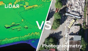
LiDAR vs. Photogrammetry: Which 3D Mapping Solution Fits Your Project Best?
In the field of surveying and mapping, choosing between LiDAR vs. photogrammetry is rarely a [...]
Th6